Stay in touch with the coast.
Sign up for our newsletter »

Educational Passages Ocean Project, Part Two

The Atlantic Circle

By Educational Passages
The wind and waves move the boats around the Atlantic Circle
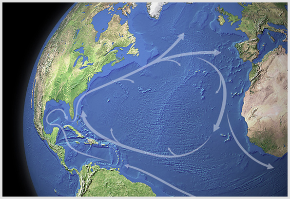
The wind and waves move the boats around the Atlantic Circle.
It was another bright sunny morning in the Northern Caribbean as the Brazilian freighter "Frenella" was making its return trip to Brazil to pick-up another load of clay to transfer back to Searsport, Maine. On the morning of November 22nd however, the ship suddenly slowed to a near stop to discharge its special cargo at sea. Students and other interested parties monitored their computers as four small unmanned sailboats were slowly lowered from the deck to the water 15 feet below and released into the ocean. The boats immediately caught the trade winds and sailed off to the west as the Race to Europe got under way. These boats belong to various schools and organizations from the state of Maine and are part of a unique learning experience. The winds and currents move in a clockwise fashion and form what is often called the "Atlantic circle" which are the forces that we hope will propel these vessels to Europe in a very "roundabout" way. There will be numerous learning opportunities as we monitor these voyages and in the coming weeks we will hear from the students and organizations that sent these boats out. We'll also discuss the unique design of the boats and perhaps hear from professionals such as sea captains, ship pilots, yacht designers and the students who help build the vessels. Here is a list of the participating organizations: Mount Desert Community Sailing Center Boat name: Island Pride Contact: Glenn Squires info@mdsailing.org Searsport Middle & High Schools and Penobscot Marine Museum Boat name: SS Vikings Contact: Kris Braga kbraga@rsu20.org Belfast Area High School (Creative Problem Solving class) Boat name: CPS Contact: Michael Lawson mlawson@rsu20.org Compass Project (Includes several Portland area schools) Boat name: Bridges Contact: Patricia Ryan pryan@compassproject.org RACE DATA Starting Point: 490 nautical miles NE of Puerto Rico LAT 24 .22 North LON 59 .01 West Starting Time: Novenber 22, 2010 at 9:50 AM EST Leading Boat: Island Pride Distance sailed: 234 nm Current Location: LAT 21.50 North LON 61.86 West Top Speed : 3.5 Knots Course made good: Southwest

Share this article: