
The Osher Map Library at the University of Southern Maine in Portland has an absolutely wonderful exhibit up now celebrating five centuries of rare maps and globes.
The section featuring Maine includes maps handpicked by Mainers, including Sens. Angus King and Susan Collins, authors Susan Minot and Monica Wood, and U.S. Reps. Chill Pingree and Bruce Poliquin. Each picked their favorite chart or map and explained what it means to them. The result is a wonderful series of love letters to Maine and her special places.
So much of our way finding today has become electronic and impersonal; we have GPS; we have Google Map; and any number of apps to tell us where to go and how to get there. These works on paper are a reminder of a time before — of navigating by the stars and plotting courses on a chart with rulers and dividers.
While they may no longer hold as much value for providing physical directions, maps have incredible value as markers of memory and of the heart, as the guest curators note.
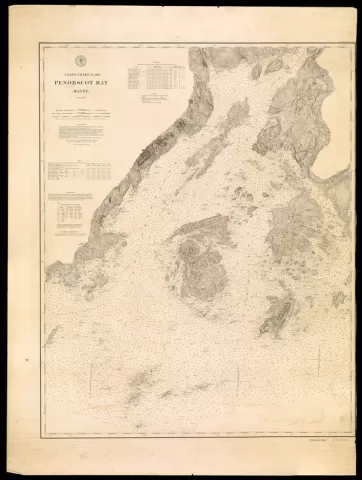
Minot picked an 1880 chart of Penobscot Bay. "Who has not gazed at a map and felt her spirit fly to imagine places," she wrote. "When the map is of a well-known area, the flights are richer and Penobscot Bay is a place most dear to me." She goes on to describe the island of North Haven, where she has spent a great deal of time, and places like the tidal river where she swims on hot summer days.
"It might as well be a map of my heart," she concludes.
Collins chose an 1877 map of Caribou, her hometown. "The straight and even property lines describe a community that earned its living from the land," she wrote. "One can easily image the potato blossoms forming rows as straight and even as the property boundaries."
Wood, who has written about her childhood in Mexico, Maine, chose an 1880 map of the towns of Mexico and Peru. "This map is made of memory," she wrote. Looking at it, I'm ten again, squinting into the summer sun, listening to my mother call me home for lunch. I feel the hot chewable factory air. I hear the churning river."
You can visit the exhibit online at: http://www.oshermaps.org/exhibitions/masterpieces-at-usm/section-7
We hope it inspires you to think about your special places and the maps of your heart and your memories.
The chart above is of Penobscot Bay, by Alexander Bache, U.S. Coast and Geodetic Survey, Washington D.C. 1880, Osher Library Collection
The Osher Map Library is open Tuesday, Wednesday, Friday 10 a.m.-4 p.m.; Thursday from 10 a.m.-8 p.m.; and Saturday from 10 a.m.-2 p.m. For more information and directions go to www.oshermaps.org or call 207-780-4850