
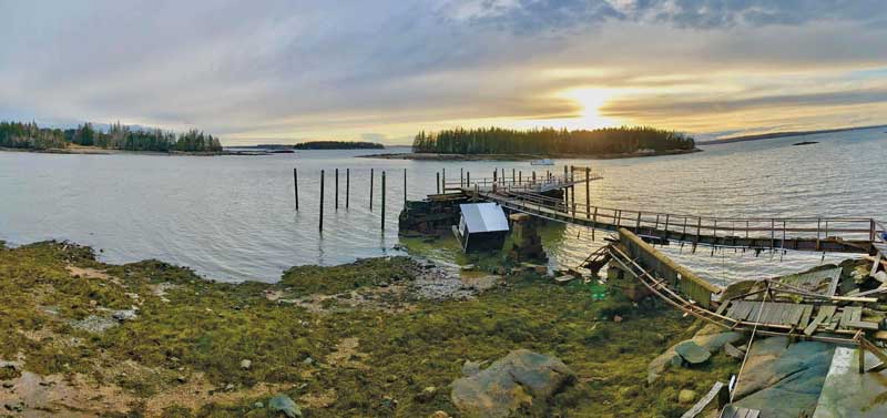
 Repairs are already underway at Brooklin Boat Yard, where high water took out the pier and damaged shoreside buildings. Image courtesy Brooklin Boat Yard
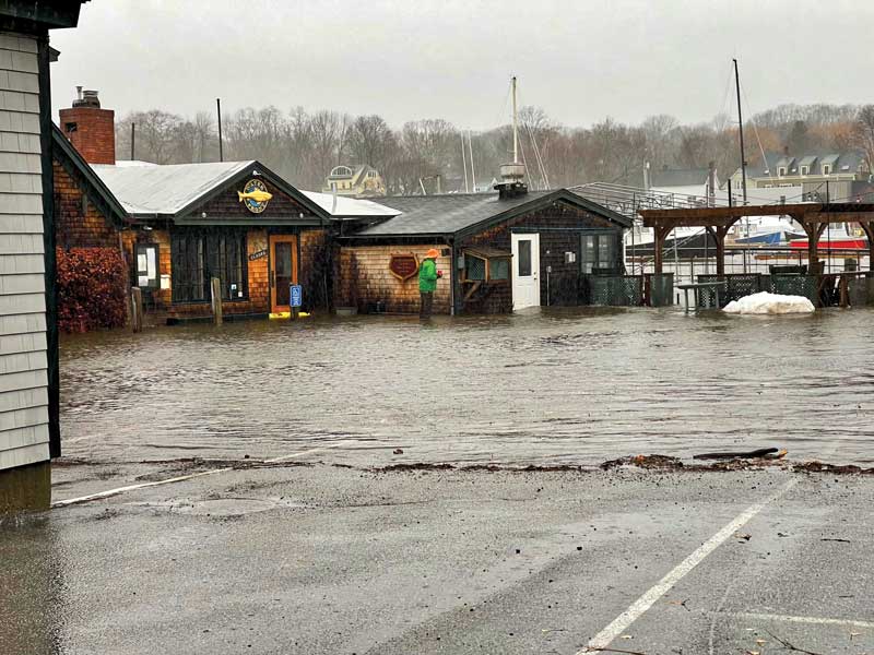
People watching seawater surge over piers and carry away buildings during the back-to-back storms that pummeled the Maine coast last January should be prepared for such flooding events to occur more frequently in future years.
That’s the sobering message officials are delivering to coastal residents and businesses as they start to assess the damage, make recovery efforts, and calculate what steps are required to make new structures such as seawalls, docks, and buildings more resilient to what may come.
The wind and waves coupled with astronomical high tides January 10 and 13, 2024, destroyed roadways and hundreds of commercial and residential wharves, toppled shorefront homes, and damaged landmarks, including many of the state’s iconic lighthouses.
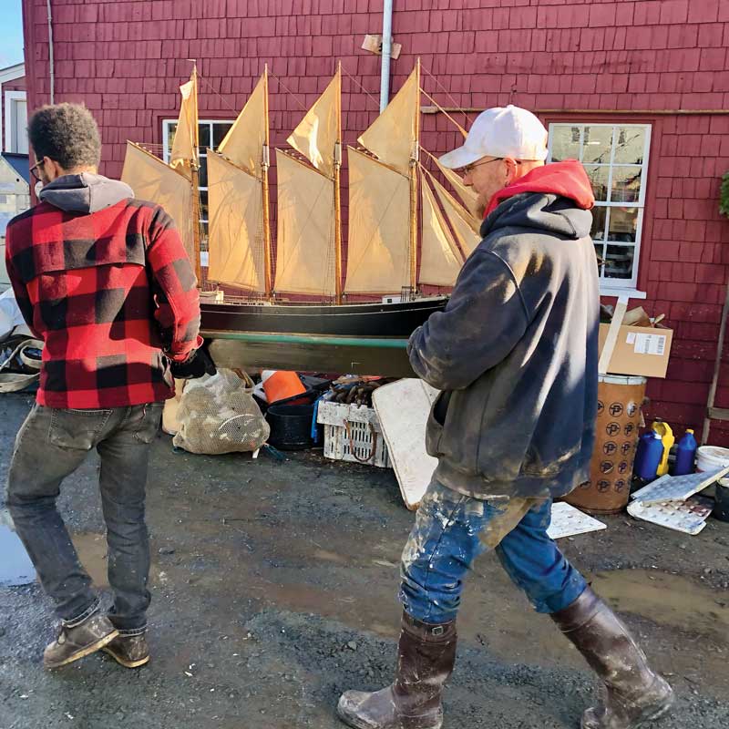 Radio, a model built by the founder of Brown’s Boatyard on North Haven, is carried to safety as volunteers help with cleanup. Image courtesy Kate Hotchkiss Taylor An increase in the rate of rising sea levels means coastal flooding events will become more common, according to William Sweet, a NOAA oceanographer and the lead author on the most recent U.S. National Climate Assessment report.
“The question is not will we have stronger storms, but what happens with sea-level rise,” he said. “It’s closing the gap between typical high tide and built infrastructure.”
The sea level in Portland, for example, rose about 3 to 4 inches between 1990 and 2020, but is projected to rise at more than twice that rate in the next 30 years, driven by water that expands as it warms and melting glaciers. A major storm tide of 4 feet above normal now has about a 2 percent chance of occurring in any given year. But fast forward to 2050 with projected sea-level rise, and those odds increase to 20 percent, he said.
What made the January 2024 storms particularly destructive was that astronomical high tides—more than 1.5 feet higher than normal, caused by the relative positions of the sun and moon—coincided with a 3- to 4-foot surge caused by gale-force winds and an atmospheric low. Water expands in response to low-pressure systems, Sweet explained.
NOAA’s tide gauge in Portland, which has been tracking tides for over 100 years, measured a record high tide on January 13 of 4.59 feet above the average high, Sweet said. Bar Harbor also recorded a new high-water mark.
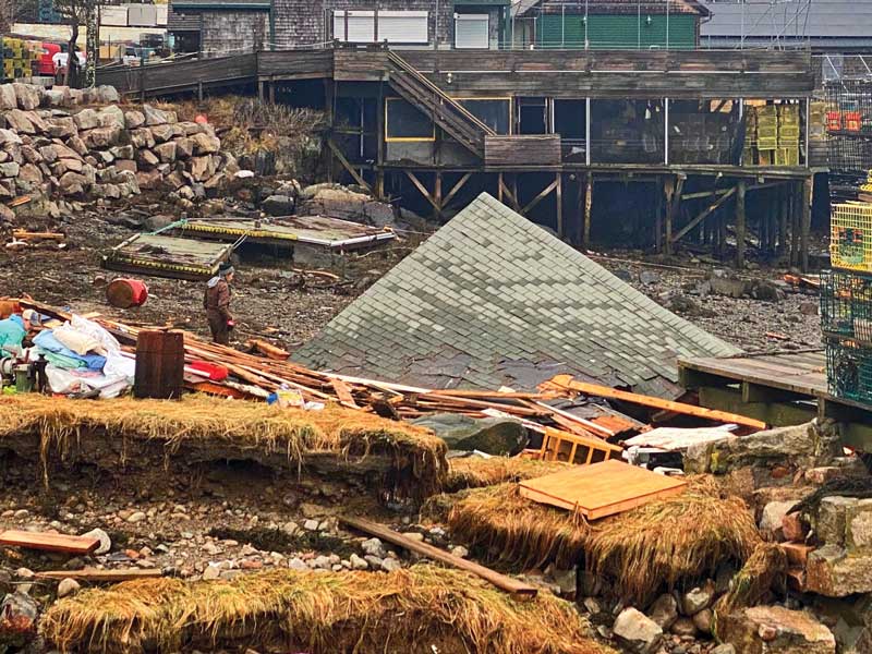 Debris litters a beach on Mount Desert. Up and down the coast, such materials that are left to wash out to sea will pose a hazard to navigation. Photo courtesy Art PaineWinds, which peaked at close to 95 miles per hour in some locations, caused water to pile up in a mass that grew higher as it came close to shore and narrow harbor entrances—a weather buoy maintained by the Northeastern Regional Association of Coastal Ocean Observing Systems on the central Maine shelf recorded wave heights up to 30 feet in the January 10 storm, and about 27 feet in the January 13 event. Also, in a shift from traditional winter weather patterns, these winds came in from the southeast—head-on to many harbors along the Maine coast.
NOAA is studying the reasons behind such changing wind patterns, which are connected to climate, Sweet said. But, he noted, “with sea level rise it’s not going to matter what direction the winds come from.”
Sea level impacts are already occurring, he added, “and they will continue to occur and will express themselves in increased heights that mean the probability of damage is only going to increase unless we do something about it.”
Even before the winter storms, a special council appointed by the governor was working on a plan for dealing with climate change. Topics for discussion include changes in shoreland zoning, permitting, better flood mapping, and setting aside funds for local climate planning. Those efforts took on greater urgency after the storms as state and federal agencies, as well as nonprofit organizations, got to work assessing the extent of the damage and how to respond.
Department of Marine Resources spokesman Jeff Nichols said agency staff flew over the coast after the first storm to assess the extent of the damage.
“We could clearly see wharves and docks, and waterfront buildings that have been hammered, destroyed, or seriously damaged beyond repair,” he said. In addition, on-the-ground inspections found less visible but equally concerning structural damage to the underpinnings of docks and piers.
DMR officials are concerned, Nichols said, about the loss of access for fishermen to land their catch and work on their boats.
“A lot of these sites that were damaged or destroyed are the points of access for fishermen and aquaculturists to get to and from the water,” he explained.
Finding supplies and contractors to rebuild the destroyed infrastructure could prove difficult. Maine Marine Trades Executive Director Stacey Keefer said she has heard from engineers and builders that they already were backed up for several years with work before the storm.
Finding money also could be a challenge, especially for privately owned structures. Most emergency relief funds are restricted to commercial entities. And private insurance can prove problematic as most policies don’t cover flood damage, Keefer said.
She said she wonders what the coast will look like in 10 years. “In maritime Canada they have massive federal harbors. Seawalls and major concrete walls to create protected harbors,” she said. “Will that end up being what we have in 10 years because no one can afford to rebuild?”
Another concern is water-borne debris from the storms.
At least one ferry run across West Penobscot Bay between Rockland and North Haven was canceled in the days after the storm because the ferry captain was concerned about potential damage to the boat from floating timbers and other materials dislodged in the flooding.
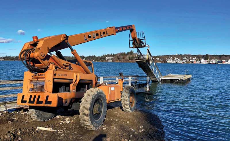 A crew removes the gangway, float, and pier from the Vinalhaven town landing on the Fox Island Thorofare after the pier was damaged in the January 10 storm. Photo by Polly SaltonstallMariners who spot really large floating debris should contact the Coast Guard, which will send out a notice to mariners, said Lt. Cmdr. Ryan Koroknay, incident management chief and public affairs officer for Coast Guard Sector Northern New England. The federal agency also wants to hear about aids to navigation that appear to be damaged or off station, he said, as well as signs of pollution such as large oil sheens. The number to call is 833-449-2407.
Maine Department of Marine Resources Commissioner Pat Kelleher has said rebuilding efforts should address sea level rise. Emergency state legislation pending in early February would loosen permitting for elevating waterfront structures by up to four feet to make them more resilient. Also pending were requests for federal emergency declarations, and state legislation to create a $50 million relief fund for small businesses hit by the January storms, as well as an earlier December storm that caused considerable flooding inland. Maine Gov. Janet Mills also has proposed budgeting another $50 million for resilience planning. (See “Online Storm Information Resources, page 73.)
The Maine Climate Council is planning for a 1.5-foot increase in sea level by 2050 and over 4 feet by 2100, said Hannah Baranes, a scientist at the Gulf of Maine Research Institute, during a webinar hosted by the Island Institute.
“We have seen a cluster of extreme flooding events since 2018 and that’s the impact of just 7.5 inches of sea-level rise (since 1920),” she said. “It’s really important to consider what several feet over the rest of the century might mean.”
 The Waterfront Restaurant in Camden was one of several businesses that were flooded by the record high tides and storm surge January 10 and 13, but was back in business by early February. Photo by Polly SaltonstallBy the end of January, many businesses already had begun rebuilding. At Brooklin Boat Yard, the high water and wind destroyed the main pier and floats, a dockhouse, and small rowboat shed that dated back to at least 1870.
BBY President Brian Larkin said he had lined up contractors and ordered materials for the rebuilding, including cedar from a local landowner who was clearing some land. Larkin planned to mill the wood at the yard.
Noting that he expects to see high water events like this more frequently in the future, he plans to raise the rebuilt pier and rowboat shed by close to 2 feet. Already extreme high-water events that used to occur every three to five years have become annual events, he said.
Like many other coastal businesses, the yard did not have flood insurance and doesn’t expect its commercial insurance to cover the damage.
“Fortunately we had money in our budget and had been planning to do much of this work already,” he said. “We are going to be fine. We should have our dock up and going and launching will be on schedule by April.”
✮
Polly Saltonstall is MBH&H’s editor at large.
Heavenly Bodies and Tides
Tides are actually long waves that roll around the planet as the ocean is pulled back and forth as the moon and the sun and associated gravitational pull interact with the Earth in their monthly and yearly orbits.
When both are close to the Earth, their gravitational pull is stronger, resulting in slightly higher tides—the moon’s pull is about twice as strong as the sun’s because it is so close to the Earth. Once about every 28 days, the moon reaches perigee, its closest point, which is when its gravitational pull is strongest, causing an increase in the average range of tides.
Typically, six or eight times each year, the new or full moon, which occurs when the Earth, sun and moon are close to alignment, coincides with the perigee of the moon. These occurrences are often called “perigean spring tides.” It is not uncommon for high tides during a perigean spring tide to be more than a foot higher than high tides during “apogean spring tides.”
These are pushed even higher when they coincide with strong onshore winds and barometric pressure changes from a coastal storm. It is expected that occurrences of minor high tide flooding at the times of perigean spring tides will increase even more as sea level rises relative to the land.
Adding to the urgency of sea-level rise is the fact that tidal ranges vary in 10-year cycles based on the planets, explained Hannah Baranes of the Gulf of Maine Research Institute. The past decade has been a cycle with low ranges, which means, she said, that tidal ranges in the next decade very likely will be higher.
Tide Tools
Understanding local predictions for tides and flooding and predicting impacts is complicated. The state Department of Transportation has funded a project to develop an easy-to-understand map where users can zoom in on their house and understand the flood risks, according to Susie Arnold, director of the Island Institute’s Center for Climate and community. That tool is due out in 2025. In the meantime, here are links to several different interactive mapping sites provided by Arnold and her colleagues.
This NOAA map allows users to type in a city and see how tide forecasts will affect them:
weather.gov/erh/coastalflood?wfo=gyx
The maine Geological Survey also has an interactive map for tracking the impact of storm surges and high tides: maine.gov/dacf/mgs/hazards/slr_ss/index.shtml
The Nature Conservancy of Maine has produced a map showing the impact of floods on roads and services: maps.tnc.org/maine/coastalriskexplorer/
Online Storm Information Resources
In the wake of January’s destructive winter coastal storms, a number of Maine groups have set up online directories to help individuals and businesses rebuild. Here is a list of some useful websites:
- Efficiency Maine Storm Recovery Resources: efficiencymaine.com/efficiency-maine-storm-recovery-resources
- Island Institute: islandinstitute.org
- Maine Coast Fishermen’s Association: mainecoastfishermen.org
- Maine Emergency Management Agency: maine.gov/mema/home
- Maine Flood Resources and Assistance Hub: bit.ly/48TAMuh
- Maine Marine Trades Association: mainemarinetrades.com/winter-storm-damage-reporting-and-resources
- Other storm-related links to online information: American Lighthouse Foundation video showing damage to lighthouses along the coast: youtube.com/watch?v=CZS9DCWWvFs
- NOAA Tide-Cycles Information: oceanservice.noaa.gov/facts/perigean-spring-tide.html