
Photos by Polly Saltonstall
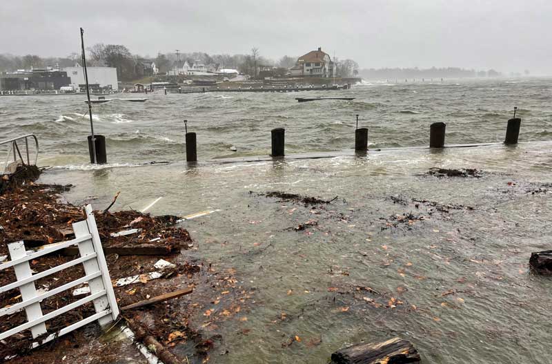
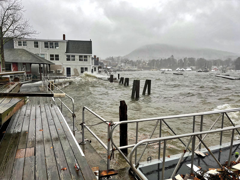 Understanding climate change and sea level rise has become an urgent issue for many of Maine’s coastal communities and islands. These photos of Camden Harbor were taken at the Camden Yacht Club during a December 2022 storm with high winds and tidal surges that caused more than $2.4 million in damages along the coast. The state identified seven counties—York, Cumberland, Somerset, Waldo, Oxford, Knox, and Lincoln—as potentially eligible for federal disaster relief funds.
Have you ever stood somewhere along the coast of Maine and wondered where will the shoreline be in 10, 20, or 50 years? If you have pondered such a thing, you might be surprised to learn that there is a hidden challenge to predicting how the sea level will change: Maine’s coastline is infinite.
Sea level rise is among the top concerns when it comes to climate change. As the warming climate melts polar ice, the oceans are filling and expanding, causing the sea to rise around the world. It might be tempting to imagine such a rise as akin to the filling of a bathtub or a water tumbler. The truth is much more complex and multidimensional. To understand the messy mathematics of sea level rise, a good place to start is to think about a simple measurement: the length of a coastline.
Some say that the coastline of Maine stretches some 3,500 miles—longer than California’s—but that, according to advanced mathematics, is a gross underestimate. For one thing, the 3,500 number doesn’t account for all the curves and inlets of Maine’s hundreds of islands and islets. But more interestingly, the coast of Maine has what mathematicians call a high fractal dimension. It means that within each nook and cranny of Maine’s coast are smaller nooks and crannies, and inside those there are still smaller ones, and so on. The waterline curves left and right around peninsulas, boulders, cobbles, and even grains of sand. One would need a truly tiny ruler to measure the delicate wiggling line that separates the land from the sea. Skipping any of these details underestimates the true coastal length. As the ruler gets infinitely small, the length of the coastline becomes infinitely long.
This is known as the Coastline Paradox. The paradox was described in the 1950s by Lewis Fry Richardson, an English mathematician and pacifist. He was studying ways to prevent war, and he hypothesized that border length would be an important factor. In his attempts to reconcile border length measurements, he managed to connect an age-old mathematical conversation about what are now called fractals, which probably had roots in ancient African architecture, to the impossibility of measuring real-world infinite curves like coastlines. Richardson’s life and scientific achievements were quite interesting beyond this discovery, but let’s return for the moment to the challenge of measuring Maine’s coastline in particular.
Suppose we do in fact have an infinitesimal ruler in our pocket, and we meander down to Whaleback Light in Kittery Point as a starting point for our measurement of Maine’s coastline. We gaze out at the seemingly timeless ocean, wondering for a long moment what the future will hold for our children as the ocean ecosystems buckle under the pressures of a heavily extractive civilization. Feeling momentarily overwhelmed, we remember that we only have a small part in this cresting wave of history, and today, that small part is to measure Maine’s coastline.
We then stroll out to the end of the pier and dig out the tiny ruler. Being very careful because of the ruler’s infinitesimal size, we lean over to start taking the first delicate measurements. But then we notice a new problem—the shoreline is moving back and forth with the waves. We can’t freeze the waves in time, so we decide to measure the high-water mark instead. But the high-water mark changes between each high tide as well. Which line do we choose? And do we include the boulders and jetties that are above water during some high tides but below water at others? In addition to its infinite length, Maine’s coastline is also constantly moving. Even with our infinitesimal ruler, we have no hope of coming up with a concrete measurement.
What seems to be a simple problem at first—measuring a coastline—turns out to be confounded by its fractal nature. It might seem esoteric, but in mathematics, fractals are the seeds of chaos, making any attempts at prediction extraordinarily difficult. It’s especially difficult on a coastline with a high fractal dimension. In the real world, with fossil fuels burning, climates warming, polar ice melting, and seas inevitably creeping their way up toward coastal habitations, making real-world calculations is essential to preparation, but where to begin?
The first step is to back away from the math for a moment and try to internalize what sea level rise really looks like. Many people seem to imagine sea level rise as a steady and gradual process. Six feet of sea level rise by the end of the century—something on the order of an inch per year—can feel manageable. Few people standing on a shore, looking out across the immenseness of the sea, fear that the water will suddenly lurch forward and grab all six feet at once, pulling them in, as well as a few buildings or a chunk of land.
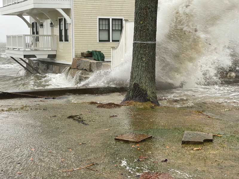 Winds gusting up to 70 MPH pushed ocean waters at high tide far above normal levels along the coast during the December 2022 storm, damaging granite piers, bridges, and seawalls, and undermining roads. While most predictions describe sea level rise as happening in gradual increments, there’s good reason to believe that in many places it could happen suddenly with unpredictable results.
People tend to focus on something they can wrap our their heads around—the average rate, which is often a small number, or the “end-of-century,” which is many years from now. This kind of model makes it easy to think of sea level rise as a problem that does not need to be solved immediately. Maybe we can just back up as the water reaches our toes, or put up a seawall and raise our bridges every 30 to 50 years.
There’s good reason to suspect, though, that the reality of sea level rise might play out a little differently. Imagine yourself as an early hominid roaming the lands between Africa and Europe roughly five million years ago. A student of geography will say, “wait a minute, how could a hominid roam there—isn’t there a large sea between Africa and Europe?” Today, of course, there is the Mediterranean Sea, where Ulysses once voyaged—the world’s largest sea, at about 2,500 miles long and more than three miles deep at its deepest point.
Yet five million years ago, the Mediterranean basin was nearly dried up. The small opening that connects it to the Atlantic Ocean—the Strait of Gibraltar—had closed, and without enough input water, the great sea gradually evaporated, leaving a deep, salty basin that an early human relative could have meandered across.
What a surprise that early hominid would have had when the strait suddenly reopened, setting off what is called the Zanclean Deluge. There’s some debate about how this happened, but there’s geological evidence, scars on the rocks, that indicate that it was a sudden event, with a thousand Amazon River’s worth of water blasting through a small opening. With the pressure of the Atlantic Ocean behind it, the torrent of seawater carved long channels in the rocks and might have shot out for miles.
The Mediterranean basin itself probably filled at such a rate that our early hominid would have seen up to 30 feet of sea level rise every day. And that single number itself is misleading, just as the rates mentioned earlier are. Because of the fractal structure of coastlines, water would have surged over rises and dips in the land chaotically, with pulses of water cresting sills and filling valleys all at once, or massive rogue waves sweeping over large swaths of land like tsunamis. Our hominid friend might have climbed a peak for safety only to ruefully witness a sea fill in all around, finally swelling over the peak itself.
It’s hard for the human mind to grasp an event of that scale. Yet many of the instances of sea level rise that we do witness occur quite suddenly and at scales that are difficult to comprehend. While there is probably no Zanclean Deluge about to happen in our lifetimes (let’s hope), sea level rise is not something to mess with.
Consider what happened in New Orleans when Hurricane Katrina hit in 2004. Sea level rise had been a concern along that part of the coast for decades, due to changes in the Mississippi River, the removal of materials below the delta, and the ongoing sea level rise occurring with climate change. When these long-term factors combine simultaneously with a large storm and a high tide, the sea can act all at once to reclaim a large chunk of land almost overnight. The storm surge that hit New Orleans was more than 25 feet high at its peak.
The basic feature of sea level rise is that while a change might seem gradual or even nonexistent, there can be a sudden jump. This is the unpredictability that comes with fractals and chaos. Maine’s coast might seem rock solid, but one can see evidence of this dynamic even in the absence of sea level rise. In Rockland, for example, on an unsuspecting night in 1996, the sea reclaimed a chunk of land and a house along Samoset Road, almost overnight.
At Popham Beach State Park, the coastline is continually sculpted and changed by movements of the Morse River. In 2009, the park built a bathhouse on the edge of the parking lot, only to see the coastline suddenly carve its way inland later that year, threatening to take the new building with it. In a last ditch effort to save the bathhouse, the park built a seawall using fallen trees from the surrounding area, hoping to absorb some of the erosive energy of the tides and currents. Eventually beach scraping was needed to save the building. Other properties and buildings nearby, where beach scraping was not allowed, have not survived the moving coastline in years past.
These examples illustrate what is possible at a time when sea level is comparatively stable. As the rise in sea level speeds up, the challenge will be of a whole new degree. The traditional approach to managing an encroaching ocean is to use seawalls. However, seawalls tend to fail just when they are most needed—during once-in-a-century storms, which are becoming far more common. Maine has effectively banned seawalls and is seeking new solutions.
In 2021, Maine Governor Janet Mills signed LD 1572, A Resolve to Analyze the Impact of Sea Level Rise. It will be interesting to see what we learn. For a curious reader, a good starting point is to check out NOAA’s Sea Level Rise Viewer—a map where you can dial sea level rise up to 10 feet and see what the inundation might look like in places like Portland’s Back Cove, downtown Belfast, or Vinalhaven. The map shows my own lab, at Bigelow Laboratory, as being located on an island rather than a peninsula at somewhere between six and eight feet of sea level rise. You can find the site HERE.
This mapping tool is only a starting point. It uses the simple approach that I decried earlier—imagining that the sea fills steadily and evenly like the filling of a bathtub. There’s none of the chaos of real-world coastlines in there. The challenge for Maine, like many other places, will be to try to foresee where those unexpected lurches and jumps in sea level might occur, and how to get ready for them. According to LD 1572, we are preparing to manage for a potential sea level rise of 8.8 feet by the year 2100.
There are some instructive successes in other parts of the world. In the Netherlands—a country that is already largely below sea level—they have discovered that the best approach is to let the sea in. As the tide rises, large canals carry the ocean through cities and over highways, channeling and absorbing the power of the water and sending it back out whence it came. They have made something chaotic into something regular and predictable.
There are also cautionary discoveries. Additional sea level rise can occur due to changing ocean currents. Think of stirring a coffee cup—as you stir faster, the current that you create makes the surface higher in some places than others. A recent study on the Gulf of Maine predicted that additional sea level rise will occur in Maine due to changes in the position of the Gulf Stream. The Gulf Stream is like that stirred coffee, and as it moves, it changes the sea level along the shore.
The coastline of Maine has shifted many times since the last ice age, and we’re once again entering a period of change. While scientists try to calculate just how and where the coastline will move, the literature explaining LD 1572 probably captures a mathematical challenge even more daunting than fractals: “The exact trajectory will depend in large part on humanity’s success in curbing greenhouse gas emissions.” You can find that report here: https://www.maine.gov/future/sites/maine.gov.future/files/2021-05/GOPIF…
✮
Dr. Nicholas R. Record is a Senior Research Scientist at Bigelow Laboratory for Ocean Sciences.