
Illustrations by Jan Adkins
It all started with a misadventure: My friend Susan and I had planned to hike Long Pond Ledges in Sullivan, but between not having enough time to download a trail map before setting out and a hard-to-read sign at the trailhead, we climbed instead the Tucker Mountain Trail.
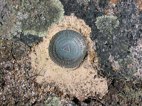
Or so we learned, when after a steep climb and the first stupendous view over Frenchman Bay—complete with a cruise ship bound for Bar Harbor and the lacy streak of the tidal falls—we stumbled on a bronze disk embedded in weathered pink granite. It told us that we were at the top of Tucker Mountain. This was after we’d passed the last Frenchman Bay Conservancy trail marker, wound down a grassy road in hopes of finding Long Pond, and then doubled back. After retracing back up and around the top again, we finally noticed several cairns. Each marked one of four Tucker Mountain benchmarks scattered around the summit. The weathered green cast-bronze disks were stamped 1934 and later dates.
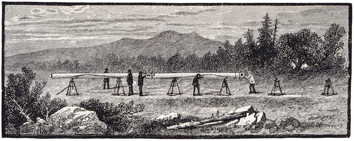 An 1857 Coast Survey party measuring the Epping Plains Base. Heavy equipment and delicate tools were carried up steep slopes and through thick woods on foot. Image courtesy NOAA
 Courtesy University of New Hampshire, 1930 SurveyAs a mapmaker and explorer of my home territory around downeast Maine, I already knew a bit about benchmarks and what they represent. I’d encountered them before, and knew they were part of a historic system of baseline survey mapping for U.S. Geological Survey (USGS) topographical maps and nautical charts. I’d seen some of the vertical (elevation) benchmarks and matched them to their labels on topographical maps. I’d also read a fascinating article in Working Waterfront (“Known Positions,” by Catherine Schmitt) celebrating the 2007 bicentennial of the Coast Survey, precursor of the National Geodetic Survey, now a branch of the USGS and the National Oceanic and Atmospheric Association (NOAA). The article, which is cached online (workingwaterfront.com) gives an overview of the history of the U.S. Coast Survey and the system of triangulation that was used to map the eastern United States with the goal of preventing shipwrecks along that extremely important coastal shipping corridor.
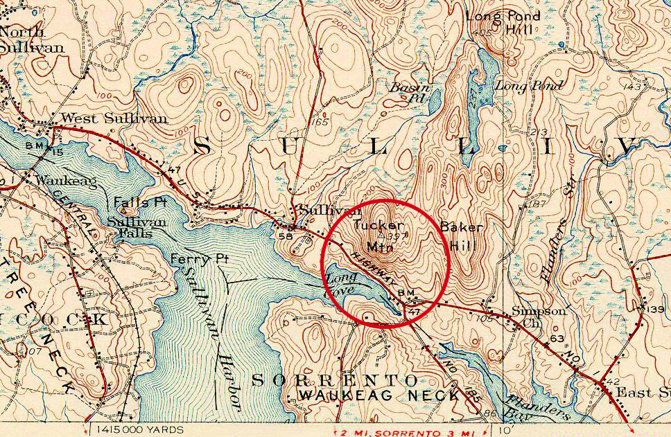
 The benchmark that began the author’s quest, shown on a 1930s topographical map (above).Shortly after I’d read Schmitt’s article, friend and veteran forester Gordon Mott showed me a benchmark disk on a summit along Eggemoggin Reach, near where I live on the Blue Hill peninsula. He said it was one of Maine’s older triangulation stations and a landmark of mapping history. Remembering this brought Tucker Mountain’s benchmarks into focus: Of course, that steep near-coast summit must have been another key triangulation station! Especially with not one but four bronze disks, marked by well-maintained cairns. This must be an important site not just for mapping history buffs, but for benchmark hunters. Benchmark hunting is a variant of geocaching. In geocaching, participants use Global Positioning System (GPS) coordinates to find containers cached in outdoor locations worldwide. Benchmark hunters also use GPS, plus written National Geodetic Survey instructions, and other techniques to find survey markers and other items within the United States.
 But why four disks close together on one summit? At least one had an arrow pointing from N to 1. Did that mean, “Go this way to find Tucker benchmark number 1”? Come to think of it, we’d noticed another bronze disk embedded in ledge at Long Cove, where we’d parked opposite the trailhead. That one marked the sea level.
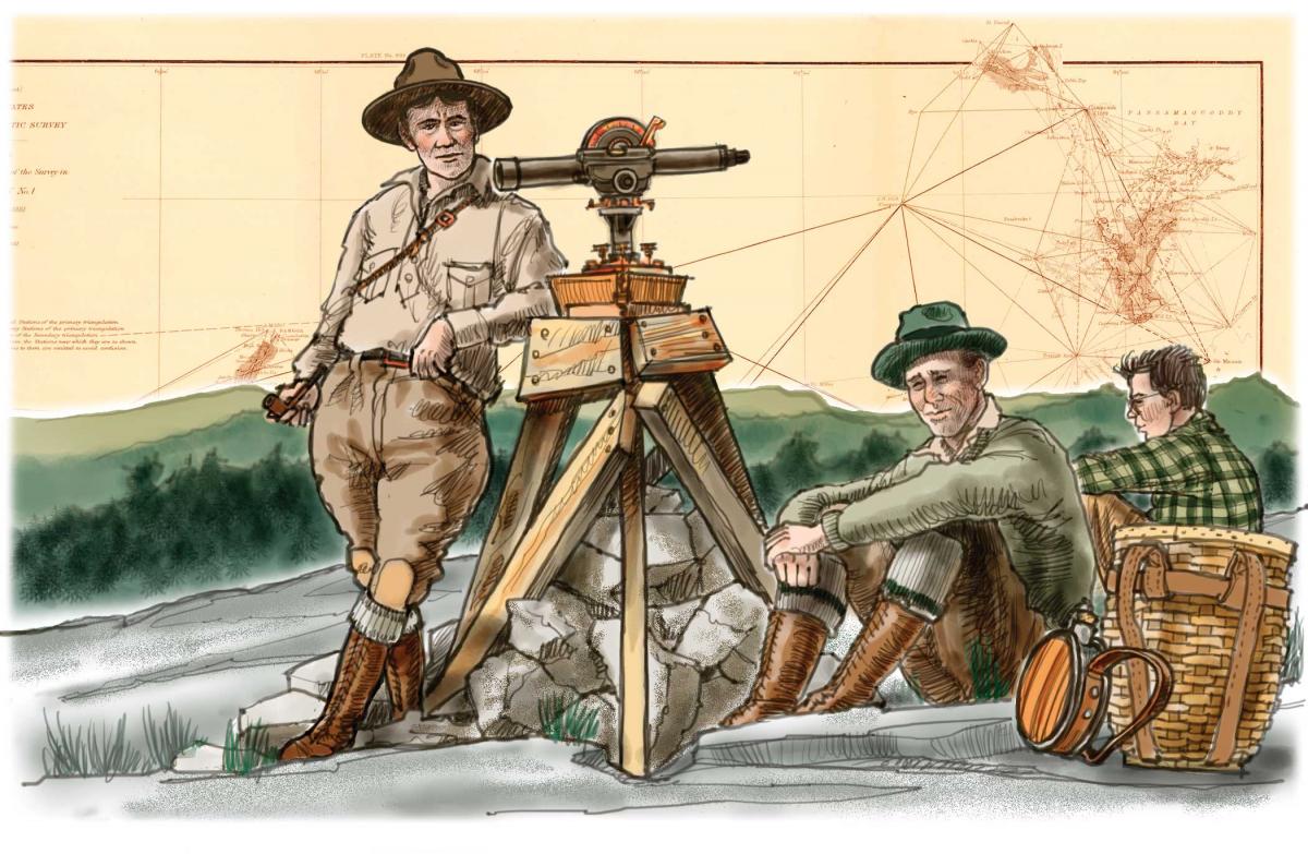
Created by President Thomas Jefferson in 1807, the U.S. Coast Survey was tasked with carrying out a comprehensive geodetic survey to provide a common reference system for maps and nautical charts. Before surveyors could map the depths of the ocean, they needed to establish known positions on land, both vertically (elevations at and above sea level) and horizontally between points known as triangulation stations. Once they had two ends of a measured baseline, surveyors could fix on a third point—a visible summit, church spire, chimney, island promontory, or other visible landmark—and, by measuring the angles, compute the lengths of the three legs of the triangle. They could then incorporate these known points and calculate distances to other points without actually going there, practicing, as Schmitt put it, “trigonometry at landscape scale.”
In 1857, the U.S. Coast Survey, under Alexander Dallas Bache, established a measured baseline in Maine, one of six fundamental baselines along the Eastern Seaboard, and the only one for which evidence still remains. It is just inland from the downeast coast at Epping Plains, a wide outwash delta and ancient shoreline in the town of Columbia. Stone monuments were set more than five miles apart to mark the east and west endpoints. The square granite base of one of these historic monuments is still there; the marble obelisk that marked the western endpoint is now preserved in the Maine State Museum in Augusta. From the Epping Base, surveyors were able to extend a network of triangles upon triangles that spanned the downeast coastal region.
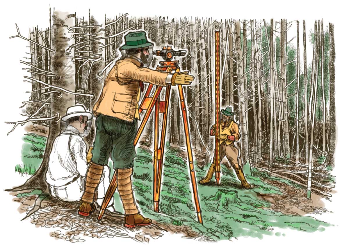
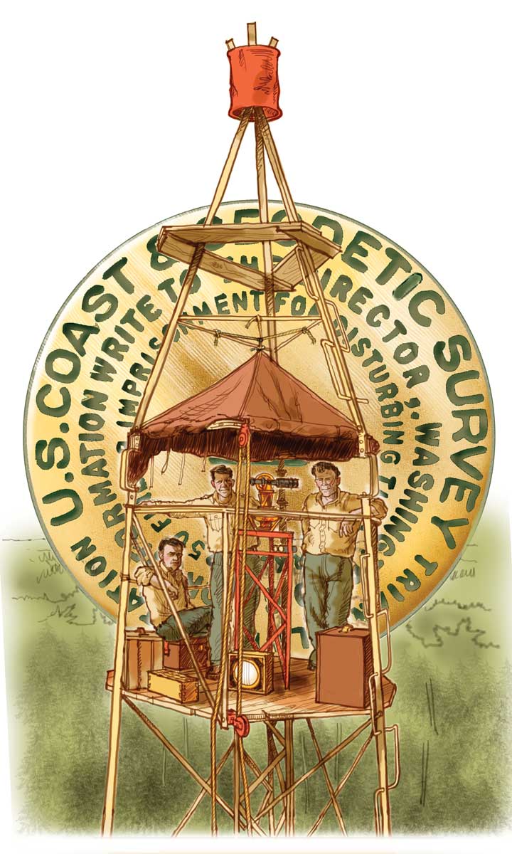
Most of Maine’s triangulation stations were on coastal summits and prominent island headlands, but some were also established inland on peaks and high ridges that were visible from the coast—Peaked Mountain (Chick Hill) in Amherst, Lead (Humpback) Mountain in Beddington, and Cooper Hill—to assure lines of sight 20 to 40 miles between stations. The angles were measured using precision telescopes aimed on points of bright light—sunlight by day, signal lamps at night—reflected by mirror targets called heliotropes at distant triangulation stations.
What grueling work it must have been, especially in the Victorian-era Maine hinterlands. Survey parties trekked through rain and across buggy meadows, lugged equipment and tools up steep slopes, felled trees to erect triangulation towers, patiently calculated where to set markers, and then sighted lines. They often worked at night when atmospheric distortion was less.
The first place I always look after a hike is at a paper topographical map from my rumpled collection. Usually reading the contours and watershed lines answers most of my questions, but this time my curiosity led me to the Internet. I typed variations on “Tucker Mountain Sullivan Maine benchmark triangulation,” which brought up a series of “e-cairns” marking the way to discovery: an old book (Geodesy: Triangulation in Maine, by Walter Ford Reynolds, USGS), which lists horizontal benchmark stations by region; a geocaching web site with a page of National Geodetic Survey notes on Tucker and more recent postings and photos of its benchmarks; and a trail history web site with a link to the NGS database and tips on how to look up survey data sheets.
The word geodetic derives from geodesy, “a branch of applied mathematics concerned with the determination of the size and shape of the Earth and the exact position of points on its surface.” As described by Wikipedia, the use of triangulation to measure distances, based on the law of sines and the relationships between angles of a triangle and their opposing lines, goes back to
classical Greece. It was practiced in ancient China and Arabia as well. In Europe,
the sixteenth-century Dutch cartographer Gemma Frisius and mathematician Willebord Snell advanced triangulation’s use in land surveying, which led to the refinement of techniques and precision tools over the next two centuries in France, Germany, England, and beyond.
Putting it all together, here’s what I figured out:
Each of those tiny, faintly labeled, hollow triangles with a dot or cross in the middle placed at certain summits and headlands and high junctions on USGS topo maps marks the site of a triangulation station that is up to a century old, or older. Each of these is labeled next to the triangle on the topo with its station name, which corresponds to its page listing in the NGS database. On this page are detailed notes on that station’s precise location and condition, updated through the 1900s by surveyors who revisit the stations roughly once a decade for maintenance purposes. At the top of each data sheet are lines indicating whether the benchmark is a horizontal (triangulation) station, tidal station, or other type of marker, followed by the “box scores” listing nearby “trig-stations” and their coordinates.
Many of the triangulation stations date back to the 1850s, which is when survey parties began working their way up the Maine coast. In general, the stations listed by name, rather than by four-digit number, seem to be the oldest. The first “monuments” were copper bolts drilled into rock, as at Fort Knox in Bucksport; later ones were cast-bronze disks embedded in exposed granite. Additional bronze disks were installed as “azimuth references” or “witness monuments,” showing distance and direction to the actual station, to help future surveyors find the site in the event the station benchmark became obliterated or hard to find. This was done on Tucker Mountain with the addition of two reference disks, according to the notes. Aha! Those were the two mystery markers we had seen; they pointed to benchmarks 1 and 2.
As Schmitt observed in her article, the surveyors’ recovery notes, describing each station’s condition through the decades, “read like an epitaph of the Maine landscape, as fields became forests and pastures disappeared beneath pavement.” Sometimes the pavement wins, sometimes nature reclaims its own.
Of course I had to read the data sheets for not just Tucker Mountain, but also for my hometown triangulation station, Little Ball on Wallamatogus Mountain in Penobscot. My friend Jan and I have hiked and explored our town’s greatest mountain, which overlooks Northern and Penobscot bays, many times, and had noticed the Little Ball label on the topo map but had no idea what it meant.
Putting the Geodesy listing together with the NGS posting, we deduced that Little Ball was an old name for Wallamatogus Mountain, and that the “monument” placed there—a copper bolt drilled into a rock—must have been one of the earlier triangulation stations, perhaps as old as 1856. By 1911 the head of the bolt was reported as broken off and hard to find amid a clearing near the top of the mountain; in 1934 station recovery efforts included the installation of three bronze reference disks. The surveyor’s notes concluded, “a 30-foot tower was built over the station, and rocks which held the legs should be of advantage in recovering station.” By 1944, the last entry in the NGS recovery notes, the trail had disappeared and the station site was reported to be merely an open space in the woods. There was no mention of a tower; it was probably long since gone.
Between the notes and the triangle’s location on the topo map we had enough clues, albeit dated ones, to go on a benchmark hunt. We set off with the map and a printout of the notes, which we reread several times as we approached the summit: a ledge on the eastern edge of a clearing west of the eastern tree line, 50 meters WNW of what appears to be the highest point….
Following our noses, we wafted through the shaded understory like ghosts, stepping over blowdowns as we threaded gently upward through the hushed forest, eventually arriving at a little plateau edged with a few ledges and boulders. When Jan found three rocks piled together on a ledge, we knew this plateau had to be it, the footprint of the station.
There’s nothing like that feeling of arriving at a place marked on a map, and finding it’s really there!
There were two things we hadn’t thought of, though: One was moss. Lots of moss, thick green moss, covered every stone and ledge around what 70 years ago might have been a clearing. The second: Private property. With landowner permission, precision sleuthing and modest scraping of moss might reveal the markers. Or, like serious benchmarkers, we could go back with a compass or GPS, tape measure, probe, metal detector, and permission to find and “recover” all four markers and submit a report on their condition to the NGS.
The site felt holy and magical, though, like a forgotten Mayan tomb. It was definitely worth another look, but for now we’d let the Little Ball markers stay shrouded in the mists and mosses of time.
AFTER my epiphany I whiled away many evenings sleuthing websites and sifting through Geodesy and The Mapmakers (John Noble Wilford’s history of cartography). I spread out all my paper topos, hunted for little triangles, lined them up, and imagined constellations of downeast trig-stations as part of what created our comprehensive national system of maps and charts.
Then came a revelation: I was able to see for myself on an historic 1860s Coast Geodetic Survey map that had been uncovered by map archivist and colorist John Barrows, owner of Galeyrie in Falmouth. It intricately laid out Maine’s coastal triangulation network in detail. (Ed. note: The map is the background on pages 44-45.)
The Coast Geodetic Survey was an enormous effort that spanned the better part of a century. The time-honored triangulation method was used worldwide until global satellite navigation systems were developed in the 1980s. But the network of survey markers is the foundation of modern GPS and satellite navigation, and still provides an important check—independent of satellites—on accuracy, shifting tectonic plates, and rising sea levels. Land surveyors, architects, highway engineers, foresters, geologists, and other professionals continue to reference benchmarks in their mapping.
Triangulation stations were established not just on summits, headlands, and islands, but at strategic points along rail lines, highways, and connector roads; at lighthouses, forts, airports, and cemeteries; and in public rights-of-way. I know of at least two that are now covered by a cell or microwave relay tower.
Many historic coastal markers are now on private land; you should get the landowner’s permission before scouting benchmarks on their property. The NGS Benchmark Viewer (see sidebar on page 48) shows park lands and some preserves in light green; recent geocacher notes may mention if the mark is on land open to public access.
If you come across one of these historic benchmarks, do send in a report to the NGS and help recover a long-lost object of American mapping history. The agency, which no longer maintains stations in remote locations, welcomes such efforts and posts a recovery form and detailed instructions on their web site. Should you find a benchmark that is loose or broken, report its condition but leave it as you found it; all survey monuments are protected by law. The agency considers the monuments to be “guests” on private lands, no longer needed for geodetic purposes. If a benchmark needs to be moved, landowners should contact the agency to arrange shipment of the marker for safekeeping in a historic collection.
Ironically, nautical charts—the main purpose for the Coast Survey initiative—do not show the triangulation stations. But the topos do, and they are easy to search. So hang on to those paper maps and bring them along on your next sailing trip.
Benchmark Sites by Land and Sea
 Before surveyors could map the depths of the ocean, they needed to establish known positions on land.
If you’re interested in a trip back through time, finding and reading the benchmark monuments and enjoying their strategic views, I’d recommend you stick to bald summits and exposed headlands with public access and trails. Fortunately, thanks to land conservation and the unsuitability of such bold places to development, downeast Maine is blessed with many accessible benchmarking destinations.
Quite a few of downeast Maine’s coastal “trig-station” summits and headlands are accessible by trail on conservation land, and are well worth a hike. Two key stations on the west side of Penobscot Bay are on Mount Battie and Ragged Mountain. Moving east, findable mainland stations include Mount Percival, Moose Point, Fort Point, Mount Waldo, Dedham Bald Mountain, Blue Hill Mountain, Backwoods Mountain (Bakeman Hill) on Cape Rosier, and a few hills on Deer Isle. Of course, Mount Desert Island provided surveyors with many bold headlands for stations, including
Indian Point, Great Head, and Bernard; and several mountains, including Eliot (Savage), Acadia, St. Sauveur (Flying), Norumbega, Champlain, and Cadillac. North and east of Frenchman Bay, stations can be found on Tucker, Tunk, and Schoodic Mountains; Schoodic Head, Pigeon Hill, Great Wass Island, and others.
By boat, ferry, or windjammer, possibilities abound around west and east Penobscot bays. There are too many to list, but here’s a start: Turtle Head and Hewes Point on Islesboro, and islands to the south; Pulpit Harbor on North Haven; Isle au Haut Mountain on Vinalhaven; Compass Island; Spectacle Island in Eggemoggin Reach; Duck Harbor Mountain on Isle au Haut. From Tinker to Swans to Bois Bubert, stations were established on islands and ledges all around Merchant Row and Jericho Bay, Blue Hill Bay, Frenchman Bay, and farther east, although the data suggests many of these monuments have yet to be recovered in this century. —JC
Research Tools
A GPS receiver is not strictly needed for benchmark discovery, and in fact may be less accurate than measuring or pacing off distances. Since most NGS stations and data notes predate GPS, the descriptions rely on detailed linear measurements, geared to using a compass and long tape measure, along with the few other helpful tools mentioned elsewhere in this article.
Topographical maps: You can start by perusing these treasure maps to artifacts of mapping history. There’s nothing more satisfying than poring over paper maps or 7.5-and 15-minute topos, which can be downloaded for free from the USGS; you can search, zoom, and pan for triangulation benchmarks to your heart’s content. http://store.usgs.gov Or, visit UNH’s searchable archive of historic topographical maps. http://docs.unh.edu
Geodesy: Triangulation in Maine: This book was published in 1918 and is now downloadable as a free Google e-book. It begins with a history of the Geodetic Survey and an explanation of how triangulation was done, then moves on to an extensive searchable list of historic triangulation stations—a thousand or more across the entire state—with a summary of each station’s location. Keep in mind that many of the stations are listed under vintage place names that are no longer in use. This makes the book doubly interesting as a guide to historic place names, and helps in matching the older named stations to their NGS datasheets.
NGS Database: Using this online resource is as simple as selecting state, then county, then clicking on “Get Marks,” scrolling to the station’s name or number designation, and hitting “Get References.” Or you can search the database by latitude and longitude. Without a map interface, though, or known station designation or precise location, it can take a bit of guesswork to find the notes you’re after. www.ngs.noaa.gov
Geocaching Sites
The growing popularity of benchmarking and geocaching has spawned two other interactive websites that are helpful in the search for benchmarks. There are recovery notes recent enough to kindle some hope of finding benchmarks in the light of day, alongside a trail or marked by a cairn.
Geocaching.com: This site’s Benchmark Hunting page allows you to search for benchmarks by zip code; this brings up a list of marks within a regional radius, each linked to its corresponding NGS data sheet. With topo maps for reference, you can scroll through the list and read benchmark recovery notes, plus often there are comments or photos posted by a recent geocacher. www.geocaching.com/mark
NGS Benchmark Viewer: Based on GoogleEarth/GIS navigation software, offered by Scaredy Cat Films, this resource displays mapped benchmark icons that are color-coded with layers of information linked to the NGS and Geocaching web pages. You can simply zoom in on a location and pan your way around, “cruising” for benchmark information by clicking the links provided. http://benchmarks.scaredycatfilms.com/ME/html —JC
Jane Crosen is a Maine mapmaker, writer, and freelance editor. She lives in the town of Penobscot, on the Blue Hill Peninsula. The creator of 30 hand-drawn maps of Maine regions, she is also the author, with her husband, Richard Washburn, of Maine Mapmaker’s Kitchen: Creative, Healthy Recipes for Home, Camp, and Afloat.
Thanks to foresters D. Gordon Mott and Roger Greene, map artists John Barrows and Jamshid Kooros, and Richard Cohen and Patty Taylor at NGS for comments helpful in shaping this article.