Maine’s Inland Waters Buoy Brigade
 Tim Thurlow, navigational aids supervisor; Jake Rideout, navigational aids crew leader; and Nick Ryan, navigational aids assistant. They are standing by a 22-foot Boston Whaler that’s been in service since 1989. Photo by Clarke Canfield") The members of the state’s navigational aids team are (from left) Tim Thurlow, navigational aids supervisor; Jake Rideout, navigational aids crew leader; and Nick Ryan, navigational aids assistant. They are standing by a 22-foot Boston Whaler that’s been in service since 1989. Photo by Clarke Canfield
The members of the state’s navigational aids team are (from left) Tim Thurlow, navigational aids supervisor; Jake Rideout, navigational aids crew leader; and Nick Ryan, navigational aids assistant. They are standing by a 22-foot Boston Whaler that’s been in service since 1989. Photo by Clarke Canfield
Navigational buoys aren’t just for the ocean. Across Maine, the state maintains nearly 2,500 navigational buoys and regulatory markers on more than three dozen freshwater lakes.
A three-person team is responsible for taking care of the buoys marking navigational channels and hazards on those lakes, which are located in all but one (Sagadahoc) of Maine’s 16 counties. While the U.S. Coast Guard maintains navigational aids in ocean waters, the Bureau of Parks and Public Lands’ navigational aids team has been doing the same on lakes big and small for more than 50 years, said Tim Thurston, the navigational aids supervisor.
Maine’s inland navigational aids system doesn’t have the bells, lights, horns, or heft—ocean buoys can weigh thousands of pounds each—of the ocean markers, but the program provides an invaluable service by placing and maintaining what are essentially street signs on the water that keep boaters safe.
 Tim Thurlow with some of the hazard markers that are kept in a new boat building that was completed in 2023. Photo by Clarke Canfield
“We’re like the Coast Guard of inland lakes,” Thurston said while giving a tour of the navigational aids team’s facilities in Richmond. “We’re in charge of buoys on lakes from Sanford to St. Agatha, and Machias to Rangeley.”
The Legislature established what became known as the Maine State Aids to Navigation System in the 1960s, resulting in a system of waterway markers used on state waters to minimize hazards to navigation. The program is administered through the Bureau of Public Lands, which is part of the Department of Agriculture, Conservation, and Forestry, or DACF.
When Thurston started work here in 1986, the state took care of 900 buoys on 13 lakes. Today, he and his team are responsible for 2,455 buoys on 40 lakes. The DACF also issues permits that allow lake associations, municipalities, and others to mark hazards in another 30 lakes, which are typically smaller and have smaller buoys and anchors that must be removed each year.
Not surprisingly, Moosehead Lake, Maine’s largest lake by far, has the most buoys. Checking the lake’s 221 markers requires traveling 145 miles in a boat.
The Pemadumcook Chain of Lakes, a series of five connected lakes just south of Baxter State Park, has 198 buoys. Sebago Lake has 169. Conversely, Great East Lake in Acton has only 10 buoys.
 Jake Rideout and Nick Ryan use a hoist to lift a 300-pound concrete anchor aboard the team’s newest vessel, built by Lyman-Morse Boatbuilding. Photo courtesy Lyman-Morse
The navigational aids team is compossed of Thurston, navigational aids crew leader Jake Rideout, and navigational aids assistant Nick Ryan. Headquartered along Route 201 in Richmond, they work in offices in an old building that also houses a garage where one of their four boats is kept. A nearby 50-by-80-foot aluminum-sided building that was completed in 2023 houses three boats on trailers, two one-ton utility vehicles, buoys, shackles, 300-pound cement anchors, and barrels of the chain that connects the buoys to the anchors.
From April through October, Thurston and his team travel alone or in pairs to all 40 lakes to replace and repair buoys as needed, replace chains and shackles, and otherwise make sure everything is in order. They tow their boats behind utility trucks that carry anchors, buoys, and other supplies in the back.
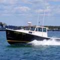
The team has four boats, the newest of which was delivered last year from Lyman-Morse Boatbuilding in Thomaston. The 22-foot custom-built aluminum buoy tender has a front console and a bow thruster that makes it easier to take care of buoys in windy conditions. A cut-out section on the port side makes it easier to load things on and off the boat. The buoy tender is powered by a pair of 115-hp Yanmar engines.
The other three boats are a 22-foot Boston Whaler that’s been around since 1989; a 1992 19-foot Boston Whaler; and a 1976 17-foot Boston Whaler. Although the boats have plenty of power—two of them have dual 115-hp Yamaha outboard engines—they are used as workhorses, not for speed.
“It’s more of a dump truck than a race car,” Thurston said while showing the 22-foot Whaler.
The cylindrical buoys that mark Maine’s lakes are made of tough, durable hard plastic and filled with urethane foam. They are kept in the lakes year-round, and they stand straight up in the water because the bottom third is filled with approximately 35 pounds of concrete ballast.
 The team’s newest boat, a 22-foot custom-made buoy tender, was delivered last year. Their other boats date back to 1976, 1989, and 1992. Photo courtesy Lyman-Morse
Throughout the boating season, Thurston, Rideout, and Ryan visit each lake at least monthly to check on, repair, and replace buoys as needed or move them if they’ve dragged out of position.
Like their ocean counterparts, red and green buoys mark navigational channels. But rather than use the familiar “red, right, returning” expression common for ocean buoys, lake boaters should think “red and green, go between,” Thurston said.
Regulatory markers are white with orange stenciling marking shallow areas, dams, and rocks, shoals and other hazards. Obstruction markers are white with black vertical strips, cautioning boaters to not pass between the buoy and the nearest shore.
To keep track of everything, Thurston has a detailed database on his computer that helps predict when parts will wear out and which buoys should be ordered in the non-boating months. The database also has GPS coordinates of each and every marker. People can view the GPS information through the Maine Inland Navigational Aids website if they have Google Earth installed on their computer.
Depending on conditions, buoys need replacing every 10 years or so. The buoy chains typically need to be replaced every five to eight years. They last longer in northern lakes because those lakes are frozen longer than southern Maine lakes and the chains don’t bounce around and swing in the wind as much.
“They’re out there 24/7, 365. You have to expect them to wear out,” Thurston said. His team on average replaces about 400 chains each year.
Marking a lake for the first time can be challenging, as Thurston experienced between 2009 and 2012 when 16 lakes were added to the program. When Thurston’s team marked the Pemadumcook Chain of Lakes, for example, they had to talk to locals who knew the waters, survey 18,000 acres of water, and identify the hazards. That done, they had to plot the GPS data, determine which buoys went where, and order materials.
In the end, they placed nearly 200 buoys, allowing people to use their boats safely and confidently. “After we finished putting out the buoys, people started using the whole lake,” he said.
Boaters appreciate their work helping identify hazards and safe boating areas on lakes, said Rideout, who has worked on the team for about 10 years. “The attaboys and thank-yous happen at the boat launches when people see us.”
✮
Clarke Canfield is a longtime journalist and author who has written and edited for newspapers, magazines and the Associated Press. He lives in South Portland with his wife.
For information and to view a map of Maine’s inland water buoys, visit the Maine Inland
Navigational Aids site HERE.
Related Articles